1995 Hurricane Season
Visuals
GOES Imagery of Hurricane Luis (WMS)
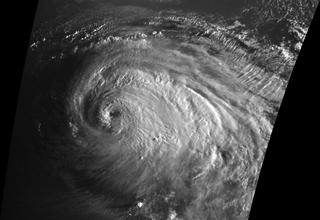
Go to this pageOn September 6, 1995, Hurricane Luis was a Category 4 hurricane located about 250 kilometers northeast of Puerto Rico. GOES-9, a new weather satellite in geostationary orbit, was undergoing a check-out period and tested a new, rapid scanning capability by taking high-resolution visible images of Luis at 22 images per hour, much more rapid than the normal rate of one image every 15 minutes. These images clearly show a number of hurricane features that had been hard to observe before, including the evolution of the eyewall structures and small-scale vortex features within the eye. It is also possible to see the formation of the new hurricane arm to the southeast of the eye. This arm is marked by the formation of clouds in the bubbling regions that indicate intense updrafts. The island of Puerto Rico can only be seen as a stationary disturbance under the bright white cloudbank to the southwest of the eye of the hurricane. ||
