Curiosity Mars rover panoramas
Zoom and pan animations of two Curiosity Mars rover panoramas from February and March 2025. The panoramic images are published at https://photojournal.jpl.nasa.gov/catalog/PIA26551 and https://photojournal.jpl.nasa.gov/catalog/PIA26552.
Curiosity was built by NASA's Jet Propulsion Laboratory, which is managed by Caltech in Pasadena, California. JPL leads the mission on behalf of NASA's Science Mission Directorate in Washington. Malin Space Science Systems in San Diego built and operates Mastcam.
For more about Curiosity, visit: https://science.nasa.gov/mission/msl-curiosity/
Curiosity Looks Downslope From the Sulfate Unit
A zoom and pan animation of the Curiosity panorama published at https://photojournal.jpl.nasa.gov/catalog/PIA26551
NASA's Curiosity Mars rover captured this view looking back down at the floor of Gale Crater from its location on Mount Sharp on Feb. 7, 2025, the 4,447th Martian day, or sol, of the mission. Curiosity was continuing its climb through a region of the mountain called the sulfate-bearing unit. What appears to be a mountain range in the distance of this scene is in fact the crater's rim. The color in this image has been adjusted to match the lighting conditions as the human eye would see them on Earth.
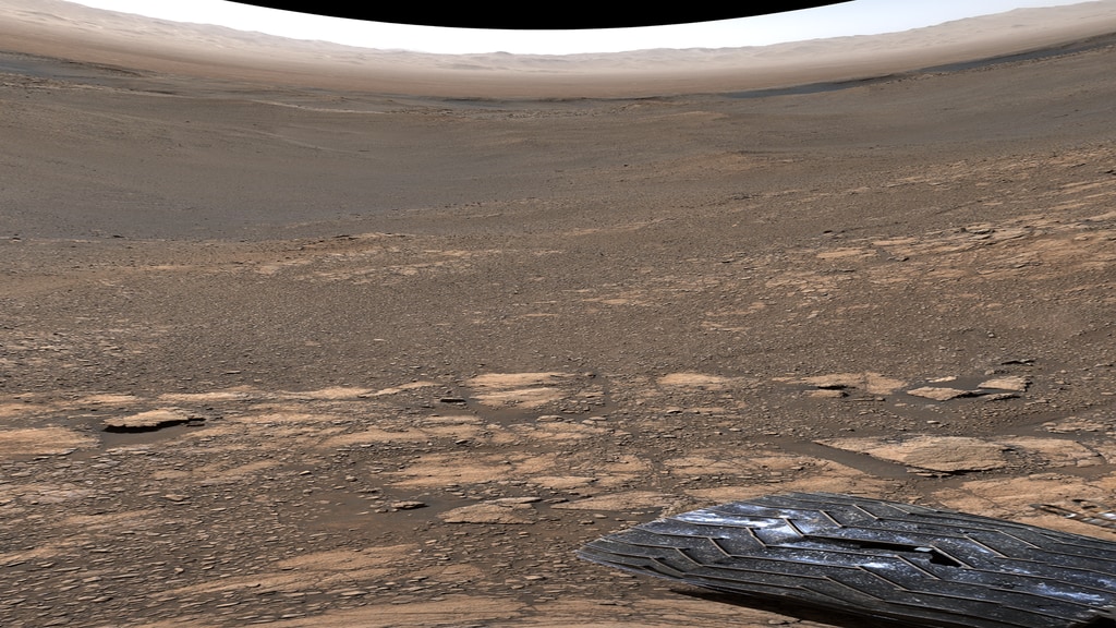
Curiosity on the Road to Boxwork Formations
A zoom and pan animation of the Curiosity panorama published at https://photojournal.jpl.nasa.gov/catalog/PIA26552
A panorama that NASA's Curiosity Mars rover captured using its Mast Camera, or Mastcam, on March 9, 2025, the 4,476th Martian day, or sol, of the mission. Steep hills on the left side of the panorama enclose wind-carved valleys on Mount Sharp, the mountain that Curiosity has been climbing for over a decade. Broken-up, rounded rocks throughout the foreground are part of the mountain's sulfate-bearing unit.
The butte in the distance at right is nicknamed "Gould Mesa." A band of cliffs and dark ridges near the top of the butte may be the first glimpses of boxwork formations, a kind of feature created by groundwater flowing through large bedrock fractures in the ancient past. Assuming that is how they formed, these could represent the last gasps of water found on this region of Mars before the planet dried out completely.
Credits
NASA/JPL-Caltech/MSSS
-
Animator
Release date
This page was originally published on Thursday, May 1, 2025.
This page was last updated on Thursday, May 1, 2025 at 5:58 AM EDT.
Missions
This page is related to the following missions:Datasets used
-
[Curiosity: Mastcam]
ID: 842
Note: While we identify the data sets used on this page, we do not store any further details, nor the data sets themselves on our site.
Related
- ID: 31140
 Hyperwall Visual