Sea Surface Temperature Anomaly and Terrestrial Water Storage Anomaly Comparison
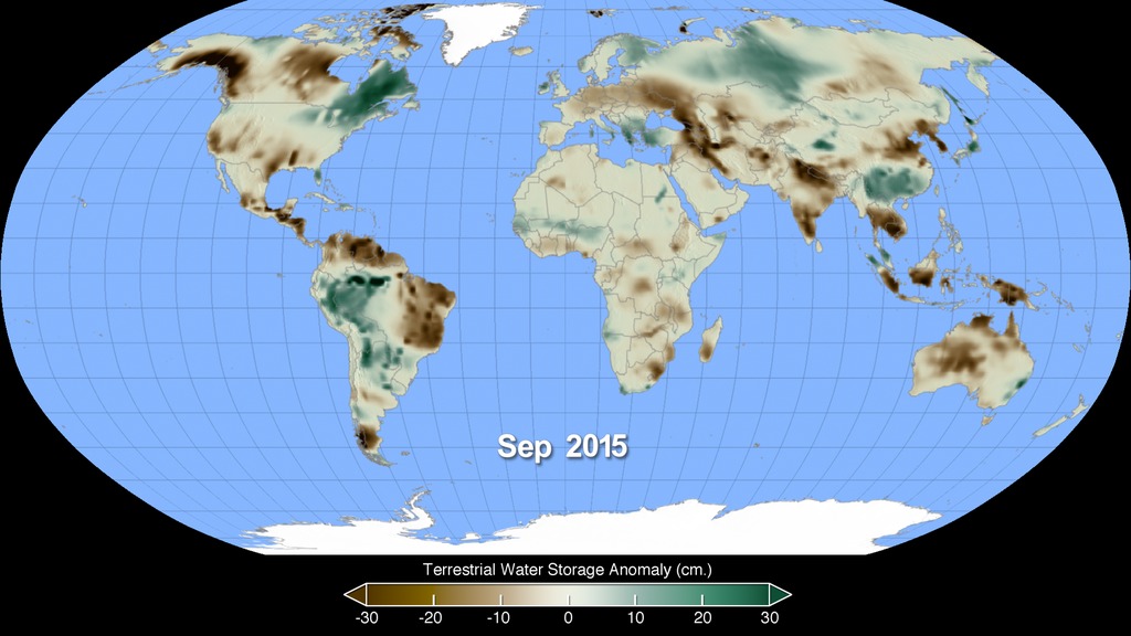
Animation showing Sea Surface Temperature Anomaly (SSTA) and Terrestrial Water Storage Anomaly (TWSA) data from 2002 to 2015 simultaneously. For SSTA data, blues indicate temperatures lower than normal and reds are areas warmer than normal. With this data we can see the comings and goings of El Niño and La Niña across the years. For the TWSA data, browns indicate areas with less ground water than normal and greens are areas with more ground water than normal, which correlates to droughts and floods in these various regions. Furthermore, terrestrial areas that show significant amounts of low water storage are much more sensitive to wildfires.
Every two to seven years, an unusually warm pool of water, sometimes two to three degrees Celsius higher than normal, develops across the eastern tropical Pacific Ocean to create a natural short-term climate change event. This warm condition, known as El Niño, affects the local aquatic environment, but also spurs extreme weather patterns around the world, from flooding in California to droughts in Australia.
Sea Surface Temperature Anomalies (SSTA) show ocean regions with warmer or colder temperatures than the long-term average for a given month. Globally, SSTA are an important driver of atmospheric circulation and rainfall patterns. Climate modes such as the El Niño Southern Oscillation (ENSO) in the tropical Pacific Ocean, including El Niño (warm SSTA) and La Niña (cold SSTA) phases, give us rise to predictable changes in rainfall patterns. The strong El Niño event that developed in 2015 appears as warm SSTA in the eastern Pacific Ocean.
For more information on the GEOS5 mission please visit http://www.nasa.gov/mission_pages/Grace/

Colorbar for Sea Surface Temperature Anomalies (in degrees Kelvin). Blue indicates temperatures that are cooler than normal, whereas reds are areas warmer than normal.

Colorbar showing Terrestrial Water Storage Anomalies (in centimeters). Browns indicate lower than average ground water saturation, whereas greens represent areas with more ground water than normal.
Flat map animation showing both Sea Surface Temperature Anomalies and Terrestrial Water Storage Anomalies for 2002-2015 simultaneously. This was used as a source for the above Robinson projected composite.
- Atmospheric/ocean Indicators
- Biology
- Biosphere
- Climate Indicators
- Earth Science
- Ecological Dynamics
- Ecology
- El Nino
- El Nino Southern Oscillation
- Environmental Governance/management
- Fire Characteristics
- Fire Ecology
- Fire Management
- Fire Occurrence
- Fire Weather Index
- Fire Weather Indices
- Fires
- Human Dimensions
- Human geography
- Hyperwall
- La Nina
- Land Surface/agriculture Indicators
- Natural hazards
- Sea Surface Temperature Anomaly
- Sea Surface Temperature Indices
- Teleconnections
- Terrestrial Hydrosphere
- Terrestrial Hydrosphere Indicators
Credits
Please give credit for this item to:
NASA's Scientific Visualization Studio
-
Visualizers
- Alex Kekesi (Global Science and Technology, Inc.)
- Cindy Starr (Global Science and Technology, Inc.)
- Kel Elkins (USRA)
-
Scientists
- Doug C. Morton (NASA/GSFC)
- Yang Chen (University of California, Irvine)
- Jim Randerson (University of California, Irvine)
Release date
This page was originally published on Thursday, January 7, 2016.
This page was last updated on Sunday, December 29, 2024 at 10:24 PM EST.
Missions
This page is related to the following missions:Datasets used
-
TWS Anomaly (Terrestrial Water Storage Anomaly) [Gravity Recovery and Climate Experiment (GRACE)]
ID: 889 -
OISSTv2 (NOAA Optimum Interpolation Sea Surface Temperature)
ID: 909
Note: While we identify the data sets used on this page, we do not store any further details, nor the data sets themselves on our site.

